 Yard Models Yard Models view Actions Open Yard Editor Yard Editor view Click the Yard Perimeter tool
Models Yard Models Yard Models view Actions Open Yard Editor Yard Editor view Click the Yard Perimeter tool
When your yard image (on page 1) and reference points (on page 1) are in place, you must set the coordinates for each of the points that make up the perimeter of the yard. The yard perimeter is essentially a polygon; individual anchor point represents the points where the yard perimeter turns.
In XPS, the number of points that define the yard boundaries is limited to 100 . See also Resolve a 'Bad array index' error in XPS (on page 1).
You cannot delete or modify a yard perimeter. Instead, you must draw a new yard perimeter over the initial perimeter. When the new yard perimeter is completed, the initial perimeter is removed.
To draw the yard perimeter:
Click  (the Draw Yard Perimeter tool).
On the map, click the corner of the yard where you want to start drawing the polygon that forms the perimeter.
A little orange circle displays.
Drag and click the next anchor point to draw one leg of the polygon.
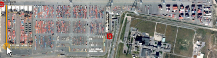
Repeat step 3 for all anchor points.
N4 colors the designated area orange.
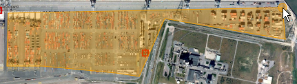
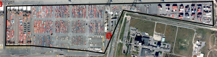
Double-click the last anchor point to finalize the polygon.
The orange markup with a solid black line.
Next step(s):
Add or place elements on the map (on page 1)